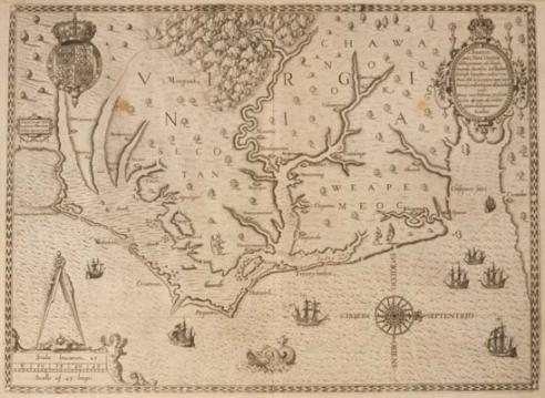
1590 John White/Theodore De Bry Map Americae pars, Nunc Virginia dicta (Frankfurt, Germany)
As an avid map collector, some of the early colonial maps are, perhaps, some of the most striking cartographic masterpieces ever printed. How the early map makers possessed the ability to draw a very accurate image of land is beyond my imagination.
The following map, over 400 years old, is a case in point. Although erroneously titled "Virginia", it's really a incredibly accurate likeness of North Carolina. Of course, shortly afterwards, Virginia was given the correct depiction when the cartographers mapped it thoroughly and accurately.
This is the first printed map showing Virginia and the Carolinas and printed right after the Lost Colony of Roanoke Island in 1590.
According to long time map expert, Philip Burden, this map, Theodore de Bry's map of Virginia, after John White, is one of the most significant cartographical milestones in colonial North American history.
It was the most accurate map drawn in the sixteenth century of any part of the new continent. And, also the most detailed drawn of the New World at the time. The diagram extends from the Chesapeake Bay to Cape Lookout.
Theodore De Bry took this image from a manuscript version from John White. White was the governor of Roanoke Colony and the grandfather of Virginia Dare, the first English child born in America (1587). White was one of the original settlers of Roanoke Island in 1585.
In 1587, White became governor of Sir Walter Raleigh's unsuccessful attempt at establishing a permanent settlement on Roanoke Island, which was infamously termed the Lost Colony. This was the earliest effort to establish a permanent English colony in the New World. Jamestown succeeded in 1607.
He was a prominent watercolor artist and mapmaker, many of his works are housed in the British Museum.
Image Courtesy of Virginia Museum of History and Culture